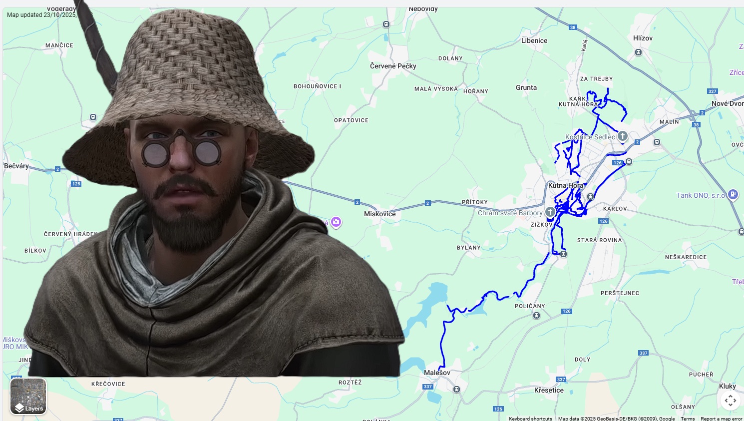
Blue Line in the KCD2 region: Explore Kutná Hora and Malešov on Google Street View
Blue Line in the KCD2 region, also known as Kingdom Come: Deliverance II: Explore Kutná Hora and Malešov on Google Street View. Do you play Kingdom Come: Deliverance II and are curious about what the real region where Henry’s story takes place looks like? Although you wake up in Miller Peshek’s bed in Rattay, the heart of the silver wealth at stake in the game was in Kutná Hora. This is exactly where we went. Our non-profit organization Digisolu walked and mapped 17 kilometers of routes that will guide you through places closely linked to the game’s history – from the Italian Court (Vlašský dvůr) to the roads towards Malešov.
Want to hear an article about mapping KCD2 routes to Google Street View? You can on Digisolu podcast on Youtube
From the Italian Court to Malešov: Which places from the KCD2 region did we map?🌍
Our mission at Digisolu is to make Google Maps better so that no pilgrim gets lost.
We put the mapping equipment on our backs and captured the places in 8K resolution
that you, as a KCD2 player, will definitely appreciate.
1. Italian Court (Vlašský dvůr) (Heart of the silver kingdom)
In the game, you collect Groschen, but it was right here, in the Italian Court, that they were minted. It is the center of power and wealth, which is why Sigismund invaded Bohemia. We meticulously mapped the entire park below the „Vlašák“ – all the paths, nooks, and even the stairs leading to the gazebo. You can virtually walk through the places where the fate of the entire kingdom was decided.
Impact: Before we mapped the park, the paths on Google Maps barely existed. Now, no Henry will get lost there.
2. St. Barbara’s Church and Kaňk (Tribute to the miners from Skalitz)
While you start in Skalitz (Stříbrná Skalice) in the game, the center of mining was actually Kaňk hill, right next to Kutná Hora. And to whom was this work dedicated? Saint Barbara, the patron saint of miners.
We mapped the entire surroundings of the monumental St. Barbara’s Church and the adjacent Jesuit College. And as if that weren’t enough, we also added a path from Kaňk to the housing estate, which offers an amazing panorama of the city – exactly the view the miners had after a hard shift.
3. Sedlec Ossuary (Atmosphere like in Sázava)
If you were captivated by the monastery in Sázava, the Sedlec Ossuary takes the atmosphere even further. We mapped the surroundings of this world-famous monument (in February 2023), which is located just a short distance from the center. You can also see the ongoing reconstruction. Opposite the ossuary is the great Coffeehood café, where you can rest with good coffee and excellent homemade desserts.
4. The Road to Malešov (Preparation for battle)
We have a treat for military history fans. We mapped the walking route along the so-called „mills“ (mlejny) and across the Velký Rybník (Large Pond) all the way to Malešov. It was near Malešov, just a few years after the events of the game (in 1424), that the famous battle took place where Jan Žižka used the terrain (and wagon forts) to defeat the Praguers. Our mapping from May 2023 ends right at the local church and school.
Fun Fact: A modern fair at a medieval monastery
As a Kutná Hora native, Zdeněk couldn’t miss one specialty. In April 2023, he also mapped the famous Sedlec fair. It’s a few centuries more modern entertainment than what you would experience at the markets in Rattay, but we think it’s the only fair in the Czech Republic that you can walk through on Street View.
Fun Fact 2: Walk along the train tracks and the historic bridge A unique view of Kutná Hora – a walk along the train tracks 😉
More expeditions coming soon
We hope you enjoyed the virtual walk through the silver region. You can find all the links to the specific blue lines in the description of our original video.
If you are interested in Google Maps and mapping, follow our website. You can find other mapped locations (not just from Bohemia) on our hub – Street View in Google Maps.
Whether you follow in Henry’s footsteps or are just planning a real trip, we wish you a happy journey.
Street View in Google Maps in Kutná Hory was mapped by the community 🌍 If you like our work, you can support it with a donation of any amount to the transparent bank account Fio 2602098198/2010
Your karma (and my french press) will be immensely grateful!🌍 Thank you! 💙
We believe that by mapping new Street View images in Google Maps, we contribute to the development of tourism in a given location. Visitors can see what it looks like in a given place at a given time and then decide whether to spend a vacation or a weekend with their family in a given location.
The Digital Solution Marketing non-profit organization aims to improve the quality of Google Maps and one way to achieve this is to map new Street View 360° images in Google Maps.
If you are a municipality, city or company and would like to map your surroundings in Google Maps, write to zdenek@digitalsolution.marketing
We operate not only in Europe 🌍
You can’t order a Google car… you can order Digisolu! 🥳
Tento web používá soubory cookie ke zlepšení vašeho zážitku při procházení webem. Z nich se ve vašem prohlížeči ukládají soubory cookie, které jsou kategorizovány podle potřeby, protože jsou nezbytné pro fungování základních funkcí webu. Používáme také soubory cookie třetích stran, které nám pomáhají analyzovat a porozumět tomu, jak tento web používáte. Tyto cookies budou uloženy ve vašem prohlížeči pouze s vaším souhlasem. Máte také možnost odhlásit se z těchto souborů cookie. Ale odhlášení některých z těchto souborů cookie může ovlivnit váš zážitek z prohlížení.
Nezbytné soubory cookie jsou naprosto nezbytné pro správné fungování webu. Tato kategorie zahrnuje pouze soubory cookie, které zajišťují základní funkce a bezpečnostní prvky webu. Tyto soubory cookie neukládají žádné osobní údaje.
Jakékoli soubory cookie, které nemusí být zvláště nutné pro fungování webu a používají se konkrétně ke shromažďování osobních údajů uživatelů prostřednictvím analýz, reklam a jiného vloženého obsahu, se označují jako nepotřebné soubory cookie. Před spuštěním těchto souborů cookie na vašem webu je povinné získat souhlas uživatele.